Plate Tectonics: How the Earth's Crust Moves
Discover how plate tectonics shapes our planet — from Wegener's continental drift to subduction zones, earthquakes, and the story of Pangea.
Discover how plate tectonics shapes our planet — from Wegener's continental drift to subduction zones, earthquakes, and the story of Pangea.
Imagine standing on solid ground and being told that the very rock beneath your feet is moving — not fast enough to feel, but steadily, relentlessly, over millions of years. It sounds impossible. Yet this is exactly what plate tectonics tells us, and the evidence is overwhelming. The ground beneath every city, mountain, and ocean basin is part of a massive, slowly drifting puzzle made up of enormous slabs of rock called tectonic plates.
The theory of plate tectonics is arguably the most important unifying idea in the entire field of geology. It explains why earthquakes and volcanoes cluster along the same narrow belts, why the Himalayas exist at all, why fossils of identical species are found on continents separated by thousands of miles of ocean, and why the map of Earth has looked radically different at various points in deep time. It is the geological equivalent of evolution in biology: a single framework that makes sense of an enormous range of otherwise baffling observations.
The story of plate tectonics begins with a controversial hypothesis—a German meteorologist’s outrageous proposition that continents drift. From those ridiculed beginnings to our modern understanding of mantle convection and plate boundaries, tectonic theory reveals the dramatic, hidden forces that continuously reshape the world we live in.
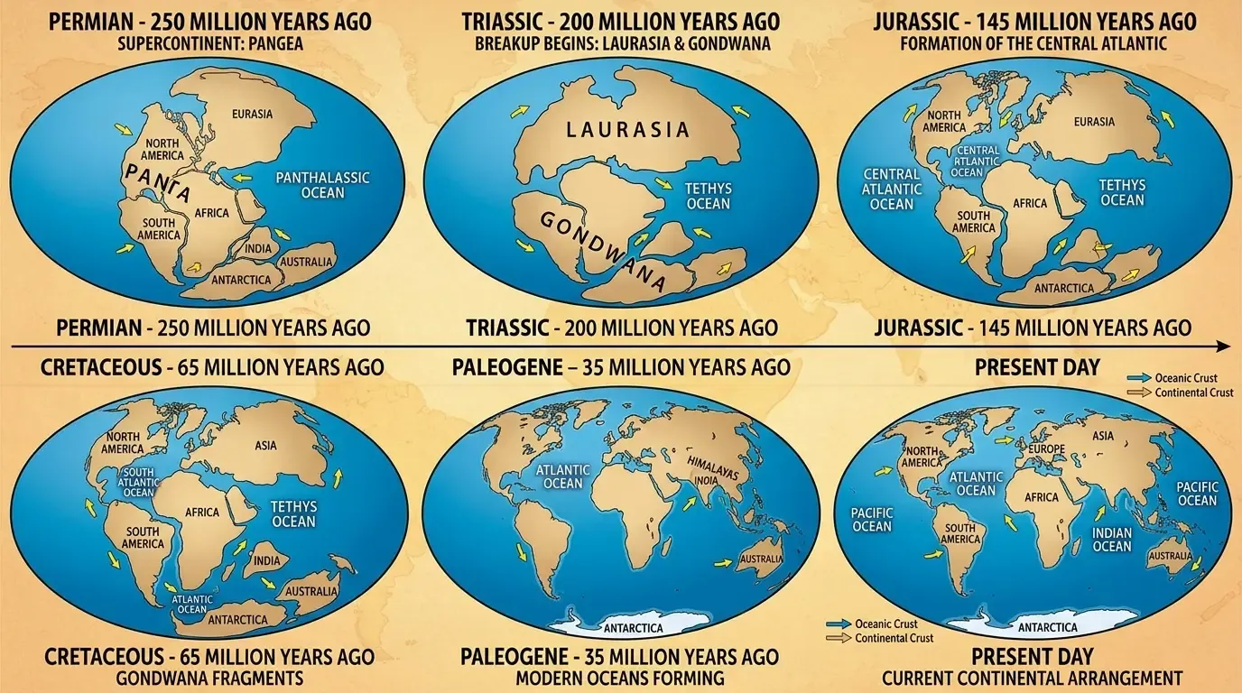
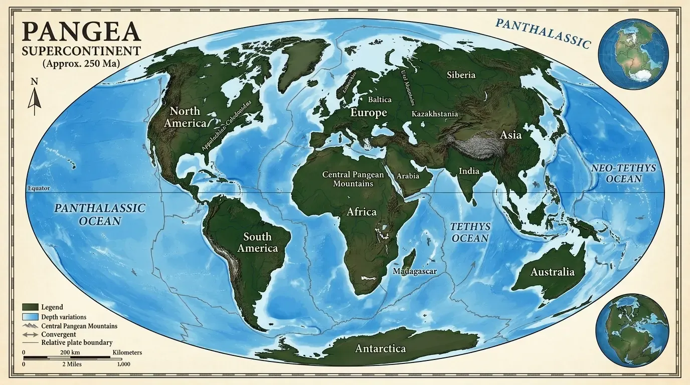
In 1912, Alfred Wegener — a German meteorologist and explorer — stood before the German Geological Association and proposed something that struck most of his audience as preposterous. He suggested that the continents had once formed a single supercontinent, which he called Pangea (from the Greek pan, meaning all, and gaia, meaning Earth), and that over hundreds of millions of years they had slowly drifted apart to their current positions.
The idea wasn’t entirely new. Cartographers had noticed since the 16th century that the eastern coastline of South America and the western coastline of Africa fit together like the pieces of a jigsaw puzzle. But Wegener went further. He assembled a remarkably diverse body of evidence.
Identical fossil species, including the small reptile Mesosaurus and the land fern Glossopteris, had been found on continents now separated by thousands of kilometres of open ocean. These were freshwater and land-based organisms — they couldn’t have swum or drifted across the Atlantic. Geological formations — whole mountain ranges and rock sequences — matched up across the Atlantic as if they had once been continuous. And there were ancient glacial deposits in tropical Africa and India, which made sense only if those landmasses had once been positioned near the South Pole.
But Wegener had a critical problem: he couldn’t explain how the continents moved. He proposed that they plowed through the oceanic crust like ships through water, driven by centrifugal force and gravitational tides. Geologists quickly showed that neither of these forces was remotely strong enough. Without a mechanism, most scientists rejected his idea. Wegener died in 1930 during an expedition in Greenland, his theory still largely dismissed.
The vindication of continental drift came from an unexpected place: the bottom of the ocean. In the decades after World War II, oceanographers equipped with sonar began mapping the sea floor for the first time. What they found was astonishing.
Running down the middle of the Atlantic Ocean — and wrapping around the globe like the seam on a baseball — was a continuous underwater mountain chain, the mid-ocean ridge system, stretching over 65,000 kilometres. At its centre ran a deep rift valley, clearly a zone of active geological activity.
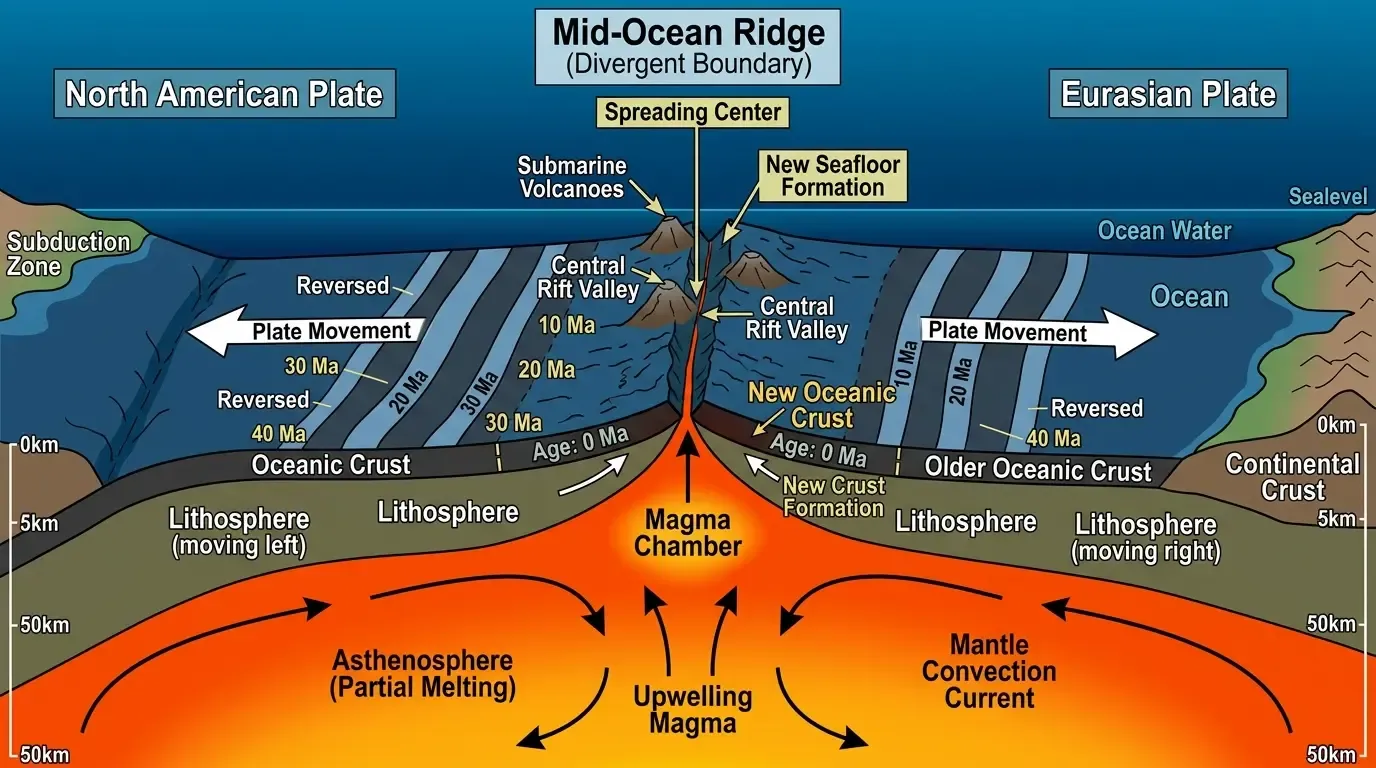
Then came an even more striking discovery. By measuring the magnetism of sea floor rocks, researchers found that the rocks were arranged in symmetric stripes of alternating magnetic polarity on either side of the ridges. This made sense only if molten rock was continuously welling up at the ridges, solidifying, and then spreading outward in both directions — a process called sea floor spreading, first proposed by geologist Harry Hess in 1960. The stripes recorded reversals of Earth’s magnetic field, preserved in rock like a tape recording of geological time.
This was Wegener’s missing mechanism. The continents weren’t plowing through ocean crust; they were being carried on it, like passengers on a conveyor belt. Scientists formally developed the theory of plate tectonics — incorporating Wegener’s continental drift and the new sea floor evidence — through the 1960s, and it is now the foundation of modern geology.
[!NOTE] The mid-ocean ridge system is the longest mountain range on Earth — but almost all of it lies beneath the ocean. The Mid-Atlantic Ridge alone runs the entire length of the Atlantic, rising above the surface only at Iceland.
Earth’s outermost rigid shell is called the lithosphere. It comprises the crust (the thin outer skin of rock we walk on) and the uppermost, cooler portion of the mantle beneath it. The lithosphere is broken into a mosaic of about 15 major plates and several smaller ones. The major plates include the Pacific Plate, the North American Plate, the Eurasian Plate, the African Plate, the Antarctic Plate, the Australian Plate, and the South American Plate.
These plates vary enormously in size. The Pacific Plate is the largest, covering more than 100 million square kilometres beneath the Pacific Ocean. Some plates carry mostly oceanic crust; others carry both oceanic and continental crust. Continental crust is thicker (averaging 35–70 km) and made of lighter, granite-like rock. Oceanic crust is thinner (5–10 km) and denser, composed mainly of basalt.
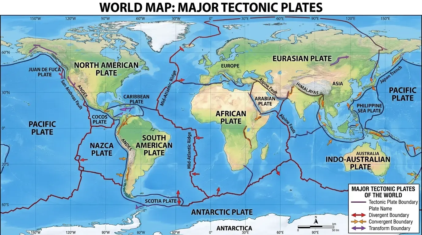
Plates move at rates that range from about 1 to 20 centimetres per year — roughly the speed at which your fingernails grow, or how fast the Atlantic Ocean is widening. Slow by human standards, but over tens of millions of years, this is enough to move continents thousands of kilometres.
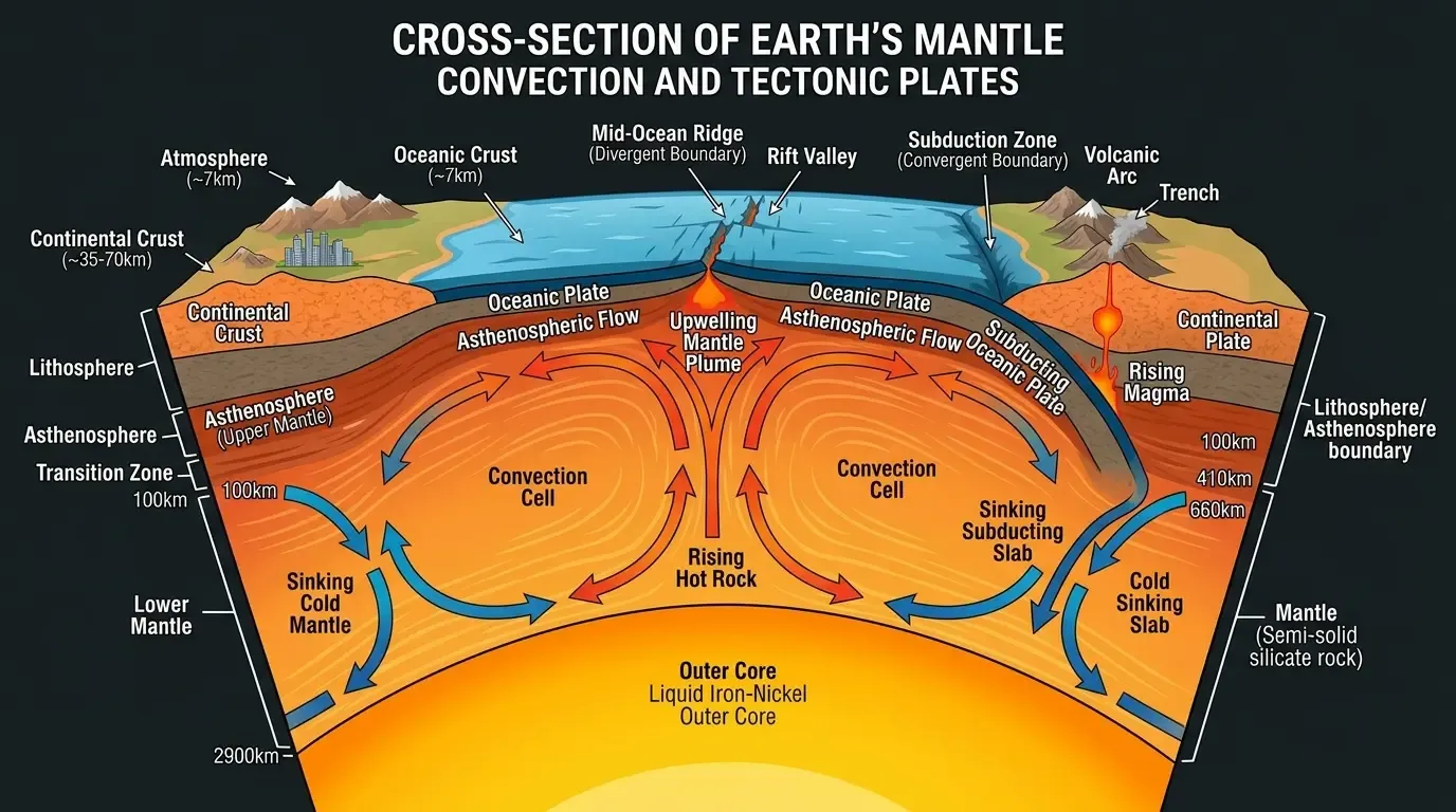
The primary driving force is mantle convection. The mantle, which lies beneath the lithosphere, is solid rock — but under the enormous heat and pressure deep inside the Earth, it behaves plastically and flows very slowly, like an extremely viscous fluid. Heat from the Earth’s interior (partly residual heat from planetary formation, partly heat generated by radioactive decay of elements like uranium, thorium, and potassium) drives slow convection currents in the mantle. Hot, buoyant material rises, spreads sideways near the top, drags the overlying plate along, then cools and sinks back down.
An additional force, slab pull, is now thought to be the dominant driver at many boundaries. When an old, dense oceanic plate descends (subducts) into the mantle at a trench, its weight literally pulls the rest of the plate behind it. A third mechanism, ridge push, occurs at mid-ocean ridges where newly formed hot rock is slightly elevated; gravity pushes the plates away downhill from the ridge. The relative contributions of these forces are still an active area of research.
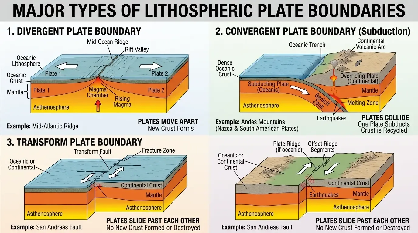
The character of geological activity at any location is determined by what kind of plate boundary is nearby — or whether you happen to sit in the interior of a plate, far from any boundary (and therefore geologically quiet).
At divergent boundaries, plates move apart. Magma wells up from the mantle to fill the gap, creating new oceanic crust. Mid-ocean ridges are the classic example: the Mid-Atlantic Ridge, the East Pacific Rise. Iceland sits directly on the Mid-Atlantic Ridge and is being slowly torn apart; you can walk across a visible rift valley where the Eurasian and North American plates are separating at about 2.5 cm per year.
Divergent boundaries can also occur within continents — called continental rifts. The East African Rift Valley is a modern example: the African continent is actively splitting, and in tens of millions of years, eastern Africa may become a separate island landmass.
At convergent boundaries, plates collide. What happens depends on the types of crust involved.
When oceanic crust meets continental crust, the denser oceanic plate is forced beneath the lighter continental plate in a process called subduction. The subducting plate plunges into the mantle at an angle, forming a deep oceanic trench on the surface. As the plate descends and heats up, water and other volatiles are driven off, lowering the melting point of the overlying mantle and generating magma. This magma rises to create a chain of volcanoes on the overriding plate — a volcanic arc.
The Andes mountain range and the Cascade volcanoes of the Pacific Northwest are both products of subduction. The deep ocean trenches off the coasts of South America and Japan mark where oceanic plates are diving into the mantle.
When two continental plates collide, neither subducts easily because continental crust is too buoyant. Instead, they crumple and pile up, forming massive mountain ranges. The Himalayas — the highest mountains on Earth — were created by the ongoing collision between the Indian Plate and the Eurasian Plate, a collision that began about 50 million years ago and continues today. Mount Everest is still rising by a few millimetres every year.
When two oceanic plates collide, the older, cooler, denser one subducts. Island arc chains like the Mariana Islands and the Aleutian Islands form this way.
At transform boundaries, plates slide horizontally past each other. No crust is created or destroyed. But the friction between the plates locks them in place for long periods, and when the stress finally exceeds the strength of the rock, the plates lurch suddenly — producing earthquakes.
The San Andreas Fault in California is the world’s most famous transform boundary. Here, the Pacific Plate grinds north past the North American Plate at about 5 cm per year. Los Angeles sits on the Pacific Plate; San Francisco sits on the North American Plate. Given enough time, Los Angeles will slide north past San Francisco.
About 300 million years ago, most of Earth’s landmass was united in the supercontinent Pangea. Before that, Pangea itself was the result of earlier continental collisions. Pangea began to break apart roughly 200 million years ago, first splitting into two large landmasses: Laurasia in the north (which would become North America, Europe, and most of Asia) and Gondwana in the south (which would split into South America, Africa, Antarctica, Australia, and the Indian subcontinent).
The Atlantic Ocean didn’t exist 200 million years ago. It is, geologically speaking, a young ocean — still growing by about 2.5 cm per year on its northern side. The Indian subcontinent has made one of the most dramatic journeys: after splitting from Gondwana, it drifted north at unusually fast speeds and collided with Eurasia, creating the Himalayas.
Earth’s tectonic plates have reorganised themselves many times over geological history. There is evidence of earlier supercontinents: Rodinia (around 900 million years ago) and possibly others even older. Geologists speculate that the current plates may eventually converge again into a future supercontinent — sometimes called Pangea Ultima or Amasia — in perhaps 250 million years.
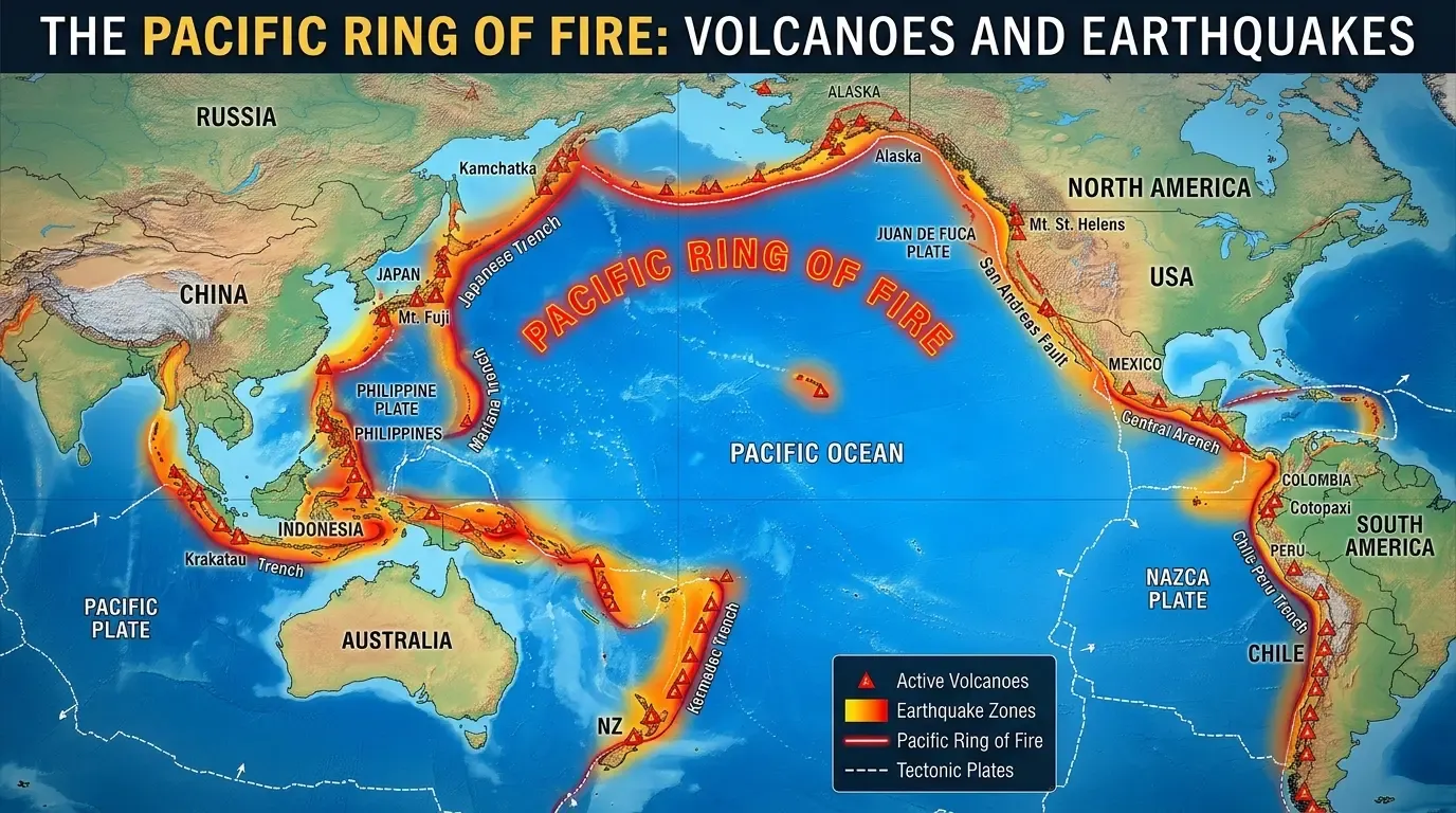
Most earthquakes occur at plate boundaries, where the stress of plates grinding past or crashing into each other is released as seismic energy. Transform faults like the San Andreas are notorious for major earthquakes. Subduction zones are capable of generating the most powerful earthquakes on Earth — the 1960 Valdivia earthquake in Chile, the largest ever recorded, occurred where the Nazca Plate subducts beneath South America.
The “Ring of Fire” — a horseshoe-shaped band encircling the Pacific Ocean — accounts for about 75% of the world’s active volcanoes and 90% of its earthquakes. It traces the subduction zones around the Pacific Plate. Beyond subduction zones, divergent boundaries like Iceland and the East African Rift are also sites of active volcanism. Some volcanoes, like the Hawaiian Islands, form over mantle plumes — hotspots where an unusual column of exceptionally hot material rises through the mantle, independent of plate boundaries.
The great mountain ranges of the world are almost all the result of plate collisions. The Alps were formed by the collision of the African and Eurasian plates. The Appalachians, now worn and rounded, are ancient mountains formed hundreds of millions of years ago when ancient continents collided — they were once as tall as the modern Himalayas.
Plate tectonics has profoundly shaped the history of life. The breakup of Pangea isolated populations on different continents, driving the evolution of distinct species on each landmass — explaining why Australia’s mammals are so different from those on other continents. The collision of North and South America created the Isthmus of Panama about 3 million years ago, connecting two previously isolated faunas and rerouting ocean currents in ways that affected global climate.
You can explore more about how geological processes connect to the history of life in our article on Introduction to Paleontology, and how Earth’s moving crust interacts with its gaseous envelope in What Is the Atmosphere?. For a long-range perspective, How Earth Will End looks at the ultimate fate of our geologically active planet.
Most plates move between 1 and 20 centimetres per year — roughly the speed of fingernail growth. The Pacific Plate is one of the fastest, moving about 5–10 cm per year. Over millions of years, this is enough to move continents thousands of kilometres.
The crust is just the outermost rocky layer of Earth. A tectonic plate consists of the crust plus the uppermost, rigid portion of the mantle beneath it — together called the lithosphere. So a tectonic plate is thicker than the crust alone.
In the very distant future — billions of years from now — as Earth's interior cools and the heat driving mantle convection diminishes, plate tectonics may slow and eventually cease. Mars is thought to have had an active tectonic history that stopped long ago as its smaller interior cooled.
Yes — the interiors of plates, called cratons, are geologically stable regions far from any boundary. Much of central North America, the Brazilian Shield, and interior Australia are examples. Earthquakes and volcanoes are rare there.
Mantle convection beneath Pangea concentrated heat under the supercontinent (which acted like an insulating blanket), eventually causing upwelling that rifted the continent apart. The exact triggers are still studied, but the process began around 175–200 million years ago.
Plate tectonics is one of science’s great unifying theories — a framework that connects earthquakes, volcanoes, mountain ranges, ocean basins, and the history of life into a single coherent story. What began as a controversial and ridiculed hypothesis from a meteorologist — dismissed because no driving mechanism was known — was confirmed by a revolution in ocean science in the mid-20th century. We now know that Earth’s surface is a constantly, slowly shifting mosaic of plates, powered by heat from the planet’s interior.
The consequences of this restless geology are everywhere: the ring of fire volcanoes that encircle the Pacific, the soaring peaks of the Himalayas, the widening Atlantic, the earthquakes that periodically reshape coastlines. And on the longest timescales, plate tectonics is one of the key reasons Earth remains habitable — cycling carbon through rocks and atmosphere, regulating climate, and continuously reshaping the conditions in which life evolves.